You probably have heard the term GIS before in your lectures or from your professor. You might have wondered what is GIS system. There are several definitions of GIS. GIS stands for Geographic Systems. It is a powerful tool for any industry or business since it allows you to analyze the demographic, environmental, as well as topographic data. The intelligence collected from GIS helps people in making informed decisions.
It has various applications, both for students and in industries. The advancements in technology have enhanced the GIS data, particularly how the data can be used and what you get from manipulating the data. GIS is of great help to students and professionals.
GIS has various sues in geographical analyze and the GIS definition geography students have is different from the uses of GIS for civil engineering or students of other disciplines. Let’s see the ways students can use GIS to help with their studies.
1. Transportation Infrastructure
If you are a transportation engineer or are studying civil engineering, you are going to learn a lot about Transportation infrastructures. With the help of GIS, you view the trends of traffic flow in conjunction with the changes in the population at the same time on one map.
You can add additional map layers if you need, such as those which show the optimum routes for any bridges in the future, etc. The GIS allows you to superimpose an unlimited amount of data over your study area.

2. Terrain Mapping
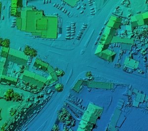
GIS technology easily transforms large amounts of data into color-enhanced, highly-detailed 3D maps. Using the data collected via aircraft and satellite sensors, underground features, soil properties, and various other geological features of an area can be mapped using GIS.
Without even having set foot on an area, engineers can identify and analyze the best locations for future developments. GIS definition geography students can make use of terrain mapping services.
3. Accident Hot Spot Analysis
Still, thinking about what is GIS system and what are its uses for Ph.D. students? With the help of GIS, one can identify accident-prone areas and hot spots. Thus, engineers and students can optimize the road networks as per the data intelligence provided by GIS.
With the help of GIS, road safety measures can be put in place, and it gives the authorities an ability to manage traffic in a better way. Structural and civil engineering students can use GIS to study these hot spots and think of ways to prevent accidents.
4. Urban Planning
GIS can analyze data regarding urban growth. Town planning students and architects can make use of GIS to plan further societies, check out sites for future development and construction, all the while keeping in mind the various factors necessary for a successful structure.
When you are writing your thesis or a dissertation as a town planning student, you will need to use GIS for various reasons. If you need any help or dissertation writing advice, there are cheap online services and blogs which can help you with that.

5. 3D interactive maps
GIS uses data to create various maps. The data which it uses come from various sources. From satellites to spreadsheets, information databases to surveys, GIS can take any relevant data and provide the students with an interactive map of the data.
With the help of Remote Sensing, data for GIS can be obtained. Drones, satellites, aircraft, etc., all collected data with the help of various sensors. The places which can’t be accessed by humans are accessed with the help of drones and satellites, and GIS helps students in analyzing the collected data in various ways. GIS definition geography students can also take help from the 3D interactive maps.
6. Watershed Analysis
Water supplies are very important. Civil engineering students, as well as environmental engineers, analyses different water structures using GIS. Following the definitions of GIS, you can study and analyze various water structure. Radiation leaks, chemical pollution, changes in the earth’s structure, etc. can threaten and damage lakes, rivers, and streams that supply our drinking water.
Digital Elevation Models help in analyzing these watersheds, but they are not great for visual analysis. With the help of GIS, you can get a numerical and graphical representation of the water flow rates, the direction of water, the depth of the waterbed, etc.
All these can be viewed on a single map using GIS. Students can combine all this data with pollution data and terrain analysis to make a more detailed study. Once you have collected all the data, you can make use of custom dissertation writing services to write your dissertations for you. Professionals will help you to write a perfect dissertation for any topic.
7. Disaster management
Engineers don’t only build things; they also provide security measures that will keep the structures safe in case of a natural disaster or calamity. GIS systems help engineers with disaster relief.
Real-time remote sensing of data helps the engineers to assess the damage and plan relief services in accordance. Mapping the area helps the students in the USA and all over the world compare previously existing data with the existing data to help with the post-relief services.
Conclusion
In this article, we have helped you understand what GIS system is by providing you with definitions of GIS and various applications of GIS for students. GIS has various applications and is a great tool that can be used both by students and professionals. Make use of GIS in your papers and Ph.D. dissertations and score better grades!
Happy Studying, Folks!