Components of GIS: Geographic Information System (GIS) is a computer system build to capture, store, manipulate, analyze, manage and display all kinds of spatial or geographical data…..
Read Here: What is Geographic Information System?
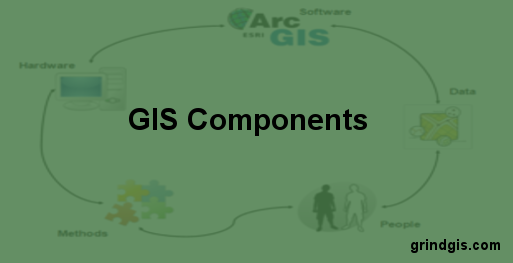
Geographic Information System Five Components.
-
Hardware:
-
Software:
-
Data:
-
People:
-
Methods:

Figure: How GIS Components integrate with each other
 Hardware: Hardware is Computer on which GIS software runs. Nowadays there are a different range of computer, it might be Desktop or server based. ArcGIS Server is server based computer where GIS software runs on network computer or cloud based. For computer to perform well all hardware component must have high capacity. Some of the hardware components are: Motherboard, Hard driver, processor, graphics card, printer and so on. These all component function together to run a GIS software smoothly.
Main Hardware Components:
-
Motherboard: It is board where major hardware parts are installed or It is a place where all components gets hooked up.
-
Hard Drive: It is also called hard disk, place to store data.
-
Processor: Processor is the major component in computer, it performs calculation. It is called as Central processing Unit (CPU).
-
RAM: Random Access Memory (RAM) where all running programs load temporarily.
-
Printer: It is output device and used to print image, map or document. There are various type of printer available in market.
-
External Disk: These are portable storage space such as USB drive, DVD, CD or external disk.
-
Monitor: It is a screen for displaying output information. Nowadays there are various type of monitor: CRT (cathode ray tube), LCD (Liquid Crystal Display), LED (Light Emitting Diodes) and more.
![]() Software: Next component is GIS software which provide tools to run and edit spatial information. It helps to query, edit, run and display GIS data. It uses RDBMS (Relational Database Management System) to store the data. Few GIS software list: ArcGis, ArcView 3.2, QGIS, SAGA GIS.
Software: Next component is GIS software which provide tools to run and edit spatial information. It helps to query, edit, run and display GIS data. It uses RDBMS (Relational Database Management System) to store the data. Few GIS software list: ArcGis, ArcView 3.2, QGIS, SAGA GIS.
Software Components:
-
GIS Tools: Key tools to support the browsing of the GIS data
-
RDBMS: Relational Database Management System to store GIS data. GIS Software retrieve from RDBMS or insert data into RDBMS.
-
Query Tools: Tools that work with database management system for querying, insertion, deletion and other SQL (Standard Query Language).
-
GUI: Graphical User Interface that helps user and Software to interact well.
-
Layout: Good layout window to design map.
![clip_image002[6]](http://grindgis.com/wp-content/uploads/2017/06/clip_image0026.jpg "clip_image002[6]") Data: The most important and expensive component of the Geographic Information System is Data which is generally known as fuel for GIS. GIS data is combination of graphic and tabular data. Graphic can be vector or raster. Both type of data can be created in house using GIS software or can be purchased. The process of creating the GIS data from the analog data or paper format is called digitization. Digitization process involves registering of raster image using few GCP (ground control point) or known coordinates. This process is widely known as rubber sheeting or georefrencing. Polygon, lines and points are created by digitizing raster image. Raster image itself can be registered with coordinates which is widely known as rectifying the image. Registered image are mostly exported in TIFF format. As mentioned above, GIS data can be Raster or Vector.
Data: The most important and expensive component of the Geographic Information System is Data which is generally known as fuel for GIS. GIS data is combination of graphic and tabular data. Graphic can be vector or raster. Both type of data can be created in house using GIS software or can be purchased. The process of creating the GIS data from the analog data or paper format is called digitization. Digitization process involves registering of raster image using few GCP (ground control point) or known coordinates. This process is widely known as rubber sheeting or georefrencing. Polygon, lines and points are created by digitizing raster image. Raster image itself can be registered with coordinates which is widely known as rectifying the image. Registered image are mostly exported in TIFF format. As mentioned above, GIS data can be Raster or Vector.
GIS Data Types:
-
Raster: Raster image store information in a cell based manner. It can be aerial photo, satellite image, Digital Elevation Model (DEM). Raster images normally store continuous data.
-
Vector: Vector data are discrete. It store information in x, y coordinate format. There are three types of Vector data: Lines, Points and Area.
 People: People are user of Geographic Information System. They run the GIS software. Hardware and software have seen tremendous development which made people easy to run the GIS software. Also computer are affordable so people are using for GIS task. These task may be creating simple map or performing advance GIS analysis. The people are main component for the successful GIS.
PLEASE READ: 67 GIS APPLICATIONS
![clip_image002[12]](http://grindgis.com/wp-content/uploads/2017/06/clip_image00212.png "clip_image002[12]") Methods: For successful GIS operation a well-designed plan and business operation rules are important. Methods can vary with different organizations. Any organization has documented their process plan for GIS operation. These document address number question about the GIS methods: number of GIS expert required, GIS software and hardware, Process to store the data, what type of DBMS (database management system) and more. Well designed plan will address all these question.
Methods: For successful GIS operation a well-designed plan and business operation rules are important. Methods can vary with different organizations. Any organization has documented their process plan for GIS operation. These document address number question about the GIS methods: number of GIS expert required, GIS software and hardware, Process to store the data, what type of DBMS (database management system) and more. Well designed plan will address all these question.


gourangadev sardar
13 Nov 2017excellent
Jim
21 Dec 2017that was very helpful to me,,
thank you
admin
28 Dec 2017Thank you Jim
Isaac Adjei Ofori
28 May 2022This is a very good piece but please if you do not mind, i would like an answer to this question.
What Gis component is mostly overlooked when validating a gis output?
admin
25 Jun 2022Sure, please go ahead.
Azif
16 Feb 2018Really appreciable.. Great work. Mind soothing paras. Keep up.
admin
18 Feb 2018Thank you Azif
Beguja kebede umeta
21 May 2018I am thankfull for the brief and detailed explanations given about GIS components.Thank you once more!
Gayatri shelled
26 Dec 2018Very helpfull to me…..
Thank you
Lilian Pokuaa
7 Mar 2019The information was really helpful.it is so easy understand and grasp the concept.
Thank you very much
abdelrhman
29 Mar 2019specific application / decision making objectives
vita djasil
23 Apr 2019thank you very kindliy
Amandeep Anand
17 Sep 2019Awesome thanks for this tremendous job♥️
Nelson
8 Oct 2019thAnks alot google
Rama Ichsan
27 Apr 2020Thank you so much, it’s helpful :D. At least I understand the component of GIS, even though I can’t use the software such as QGIS as well as other yet.
https://ramaichsan.blogspot.com/
Maria chamisa
7 May 2020I would like you to include some references
softech
19 Jul 2021Nice article author.Thank you for such a useful sharing.
Dalie
20 Dec 2021Brief And Well explained but Would still Love To Have An Extended Reading, I Don’t If Its Possible For You To Expand This Discussion
Mathews simukoko
6 Feb 2022Very informative and easy to understand, thanks
TATENDA MAJOTO
8 Feb 2022Very helpful and well explained piece of work
Nuwan
14 Aug 2022Very helpful article
Thank you
Aggrey
17 Sep 2022This is a vivid information about GIS
James komichi
8 Nov 2022This document is well explained. Keep it up. It is very helpful.
Abhie
7 Dec 2022The information is clear and straight forward 😊thanks goggle