The geographic information system has various uses in the field of education. It can be used efficiently in several levels of informal and formal education. Besides that, GIS will connect learners to their communities. The use occurs in all levels including primary, secondary grades, and continues to university courses. In addition to that, students can learn how to use GIS at girl or boy scouts and after school programs. Here are the applications of GIS in education.
1. Emphasize concepts
Instructors are emphasizing teaching with GIS at the elementary and secondary levels. It is used to teach skills and concepts in geography, earth science, mathematics courses, history, biological science, and chemistry.
2. Research tool
Institutions of higher education including universities and colleges use GIS as a fundamental tool. It researches in disciplines such as demography, geography, and geology.
3. GIS education
Most major community colleges and universities in the states offer GIS education. Besides that, GIS has become dominant at other universities, and courses of GIS theory are taught. The course is present in disciplines like geology, environmental studies, engineering, business, and geography.
4. Enhance learning ability
Students have benefited from GIS in several ways. The use of GIS helps to enhance learning ability. Learners can think critically when solving problems and analyzing data. For this reason, they can make decisions on their own without dependency. In addition to that, students can use numeric and number skills as well as tools that process and send information.
5. Enhance linguistic intelligence
The geographic information system enhances linguistic intelligence. Learners develop reading ability and use of visual symbols. They can interpret information in for of word, for example, looking at an image of the map and interpret historical and location information.
6. Map literacy

GIS enhances map literacy. Students learn to change situational knowledge to visual pictures. They can visualize spatial patterns and engage in inquiry.
7. Display concept at once
Regardless of several quality tutorials, textbooks, and courses, learning technology and its applications is a challenge to educators and students. A geographic information system is a combination of technological tools, procedures, and methods. Henceforth, it displays many concepts at once and students are supposed to grasp. The instructor should master special concepts when teaching GIS then present well to the proper audience.
8. Internet-based GIS replaces the software
GIS does not need software beyond a web browser. Some educators are faced with challenges like school technology and installing software. Browser applications are essential. Moreover, web-based GIS needs less time to learn hence minimizes the time required for educators to introduce them in the curriculum.
9. Analyze dynamic content
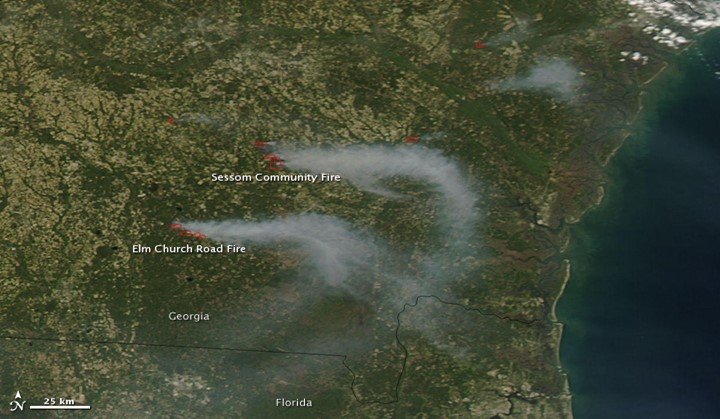
It is difficult to analyze more dynamic content such as wildfires and earthquakes on the desktop. The geographic information system has a great advantage over desktop when it comes to watching online. Most countries have licensed online information thus it is easy to access without experiencing restrictions or costs.
10. Planning
Besides classroom use, the school uses the tool to plan facilities such as technology infrastructure and room capacities. Additionally, it determines the effective implementation of resources and programs. It plans other administrative activities including recruiting students and managing alumni networks.
11. Safety
Safety is significant for learners, teachers, and school staff. With the use of GIS, institutions can prepare for an emergency.