
GIS stands for Geographic Information Systems. Various applications use the systems to generate data that is useful in the respective fields. Technological and industrial areas have enhanced the use of GIS data to achieve their goals. Businesses have also adopted GIS data in decision making, where they can analyze the environment for the viability of the ventures.
The following are some of the uses of GIS Data:
1. Mapping
Several professions use maps in communication. GIS simply provides a visual interpretation of data so that users can easily identify locations.
2. Telecom and Network Services
These industries have a complex network format and GIS applications help in incorporating geographic data within the format. In the telecom field, this data enhances the application and management of customers
3. Analysis of hot spots and accidents
A GIS helps in traffic management, where police can use data to minimize road accidents. Through an analysis of road networks, authorities can establish locations that are hazardous.
4. Urban Planning
GIS technology is used to track the growth of populations in urban centers. Urban planners use the information to identify sites that need to be expanded to accommodate the populations.

5. Planning of Transport networks
GIS data is used to collect topographical data, which is used by transport departments in solving logistical problems. Data about environmental challenges can also be sourced through GIS.
6. Environmental Impact Analysis
Humans encroach on the environment and their activities may have adverse effects. GIS is used in the analysis of the magnitude of such activities to inform people about the impending danger.
7. Agriculture
Farmers have adopted GIS technology as a source of information on farming techniques to be used. GIS data has also enabled them to analyze soil types and the crops that are suitable.
8. Disaster Management
GIS data helps in identifying areas that have high probabilities of experiencing disasters. Information gathered is used to generate preventive measures.
9. Landslide Hazard Zonation
Areas that are prone to landslides can be classified according to the degree of danger. The complexity of this task requires the use of GIS data.
10. Determination of changes in land use
Natural forces have effects on land use and this may be very difficult to notice. GIS data is essential in tracking the changes that may arise from factors such as deforestation.
11. Navigation
Water vessels rely on GIS technology to identify routes and waterways. This minimizes the possibility of collisions and injury from water accidents.
12. Estimation of Flood damages
GIS can be used to generate visual maps about an area that is prone to flooding. If there is a high potential in a particular area, authorities will plan for relevant rescue and relief missions.
13. Management of Natural Resources
The environment consists of factors such as water, forests, soil and air. GIS is used to monitor the changes in these items to inform concerned parties to act.
14. Banking
GIS data is used by bankers to assess the market and responsiveness of customers. As a result, they can plan, organize and make decisions.
15. Soil Mapping
Farmers who are interested in buying land will use GIS data to establish the types of soils
in the area. They can decide on the crops to grow as well.
16. Digital Taxation
Governments can eliminate tax evasion problems by developing a digital system. Essentially, the system creates harmony between agencies hence reducing fraudulent transactions.
17. Land Information Systems
A GIS-based system is comprehensive and entails all management properties. Apart from easy payments and allotments, it helps in the timely resolution of disputes.
18. Surveying
Governments have opted for this data in performing topographic surveys, which are more accurate. They can also generate maps to provide a visual impression of the area.
19. Mapping of wetlands
The technology is used to locate wetlands, which create a healthy environment. They maintain a high water table during dry seasons and reduce floods in the wet season.
20. Geology
Geology is a complex discipline that explores the structure of the earth, soils, and seismic information. The system is used to source for the critical details that are required in the study.
21. Coal Mining
Coal mining frequently experiences fires that cause risks to the miners which are cons but this industry is growing fast. So, GIS data is used to monitor spontaneous combustion so that workers take precautions.
22. Managing and Maintaining Assets
Through GIS, companies can develop mobile applications that boost efficiency. While in the field, workers can process information promptly and transmit under minimal costs.
23. Community Development
GIS is a scientific tool that seeks to create solutions to community problems. The rapid rates of innovation have improved lifestyles by providing technological appliances.
24. Dairy Industry
A system is a planning tool in the dairy industry. Farmers can monitor prices, distribute products and also locate prospective customers through this data.
25. Tourism
Applications generated from GIS can help tourists to identify potential recreational destinations. They simply need to click on links that will guide them in finding hotels, distances and prices.
26. Irrigation
The technology is used together with satellite remote sensors to establish ground information on evapotranspiration and the amount of water needed in a particular field.
27. Analysis of Fire Equipment Response
GIS data provides urban planners with information about street networks. This enables them to locate stations where firehouses can be erected.
28. Trends in Earthquakes
Information on global earthquake trends is useful because seismologists and engineers need to establish patterns. The catalogs have this data that is critical in decision making.
29. Identification of volcanic hazards
Volcanic hazards can lead to loss of lives and property. This data is incorporated with volcanic activity records to inform the public about the looming danger.
30. Tracking and Planning of Energy Use
The growth of the energy industry relies on GIS data. It is a complex area that requires planning and diligent execution of decisions. GIS also helps stakeholders in this sector to cut costs.
31. Fisheries Industry
The management of fisheries requires a system to generate spatial data. GIS is used to create this data and also minimize costs. Fish farmers use GIS to deter illegal fishing as well.
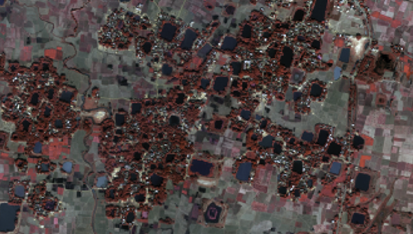
Identified water bodies suitable for fish-farming using Hexagon Geospatial’s ERDAS IMAGINE®
32. Monitoring Rangeland Resources
Rangeland supports livestock and wildlife, thus it has to be maintained. GIS is a tool that monitors ecological changes by providing accurate information about the environment.
33. Accurate Selection of reservoir sites
While locating a place to build a dam, the data is used to advise excavators to sink holes in areas that are free from natural hazards such as volcanic eruptions.
34. Zone Mapping for Forest Fire hazard
GIS helps firefighters to identify areas that are vulnerable to fires. In case a fire happens, this kind of data is critical for estimating the number of losses.
35. Control and Management of Pests
Pests reduce crop production. For farmers to control them, a proper map of the infested area must be developed through data collected from the system.
36. Studies of Traffic Density
Traffic has exponentially grown in recent times. Hence, GIS is used in traffic control because it provides information on traffic flow, road geometry and speed.
37. Deforestation
The area under forest is significantly reducing every year. The technology has been deployed to monitor deforestation so that this vice can be deterred.
38. Utilization of Space
The study of space relies extensively on GIS data. For instance, architects can have a 3D experience of a building before drawing it.
39. Desertification
Data from GIS is used to identify land which has undergone desertification. Governments can then use it to identify area can be reclaimed by planting vegetation or constructing pipes.
40. Disaster Planning
Organizations rely on this data to prepare for disasters. GIS provides information about changes in weather patterns and disaster zoning, which guides decision making processes.
41. Business
Entrepreneurs have resorted to digital trends and GIS is a platform where they can source information concerning customer location, sales patterns, among others.
42. Utilities
People can use GIS technology to monitor their utilities by tracking inventory systems, how they are maintained and the frequency at which they are distributed.
43. Lease property and management
GIS is critical in real estate because it helps in the management of space. Real estate managers can minimize costs and make queries about the land.
44. Creation of Public Infrastructure
The entire lifecycle of a facility relies on GIS data. Right from space planning to the actual construction, information regarding emergencies and response will be required.
45. Drainage in plantation areas
Plantations have varied requirements in terms of water availability. Any disparities will affect the yield. GIS data helps farmers to establish the correct quantity for a particular crop.
46. Source of information for Geographic features
GIS data provides a map of an entire locality. More specifically, members of the community can use it to locate features like rivers, roads and buildings.
47. Public Health
GIS is a cost-effective tool that is used to provide health information. Before information is disseminated to the public, GIS is used to analyze it for accuracy.
48. Identifying Locations
GIS is used to give directions to help people get to a location. The system unravels locations using items such as longitudes and latitudes or just by names.
49. Defense Purposes
GIS data is used to provide information about terrains in digital formats. It helps countries to plan how to retaliate in case they are attacked by enemies.
50. Selection of Pipeline Routes
Even though selecting a route to lay pipelines is complex, GIS has made it easy to choose the best route that is economical and has minimal negative environmental impacts.
51. Choosing a site to install a waste treatment plant
Population growth has increased, leading to greater wastes. Through GIS, analysts can locate the best sites where wastes can be recycled without affecting humanity.
52. Geological Mapping
Surveyors rely extensively on GIS data to create 3D impressions of an area. The maps guide them in scaling down the area into desired measurements.
53. Environmental Protection
There are several GIS applications that are used to monitor and analyze the changes in the environment. Professionals can solve this problem by tracing pollutants.
54. Development of Infrastructure
Professional infrastructure development is today anchored on the availability of technology. GIS systems are being used in every stage to complement other technologies.
55. Management of coastal zones
The coastal stretches of many countries have significant economic features like sand dunes and coral reefs. GIS information is used for planning on both macro and micro levels.
56. Analysis of crime
Enforcement agencies use GIS data for mapping areas that are affected. It is more efficient and the satellite images can facilitate quick investigations to curb the vice.
57. Selection of Sites to build bridges on a river
GIS provides historical information concerning sedimentation and soil erosion. Data collected also informs engineers about the slope of the channel.
58. Land Use changes resulting from mining
Governments rely on minerals to improve their export trade. However, mining can drastically affect the environment, thus GIS is used to regulate the rate of mining to protect the surrounding communities.
59. Development of the economy
Economists use the information to analyze the viability of a market. They identify new locations for new businesses and also find ways to improve the existing ones.
60. Analysis of walking distances for schools
Stakeholders in schools may adopt this technology to establish the distances that require to be covered by bus. In the course of their studies, learners can pay for research paper
to gather information on technology as well. If the distance is too short, students may be required to walk.
61. Locating underground cables and pipes
Pipes and cables are monitored underground using the systems. It is important to check for leaks so that the environment is not affected by hazardous contents being transported.
62. Conservation of coastal vegetation
Vegetation at the coast helps to protect the area against extreme weather conditions like tsunamis. GIS is used to map the coastal stretch to identify areas that have little vegetation.
63. Regional planning
Planners need to research and collect details about an area before developing it. Surveyors and engineers use the data to design cities with reference to the neighborhood.
64. Land administration
Countries have resorted to digital forms of land administration. Functions such as taxation are being executed diligently because the system is structured.
65. Prediction and mapping of snow cover
GIS data can be used by organizations to monitor the annual alterations of snow cover. The information can help them to plan for activities such as sports.
66. Management of wildlife
Human activities have led to climate change and pollution. This data is used to identify wildlife sections that have been adversely affected by international intervention.
67. Disease control
The system is used to target breeding areas for pests. Control and intervention measures can then be applied to kill them.
68. Whale and shark tracking
With mapping applications, divers can locate areas that are infested with sharks and whales. The sea animals are dangerous if not monitored.
69. Creation of conservation areas for fish
With this technology, farmers can establish how to fish has been distributed in the water bodies. The information will guide the amount of infrastructure to be built.
70. Air traffic control
Airports use this data in managing airplane landing and takeoff. The process needs accurate communication to avoid accidents.
71. Mergers and acquisitions
Companies that are seeking to acquire new businesses will find opportunities using technology. Those that wish to sell their shares will avail of information on the same channel.
72. Humanitarian assistance
Many people live under vulnerable conditions, including famine and disease infestation. Organizations track these populations using this technology.
73. Insurance
Insurance agencies use GIS technology to establish the amount of risk suffered by a client. This minimizes fraud.
74. Geoblocking
In case the owner of a website does not want people in a particular location to access the website, they can use the data to block them.
75. Target advertising
Companies can track a location that has the correct demographics
that are likely to consume their products. This system also provides census data of the area.
76. Identifying coastal hazards
The coast borders the ocean and is prone to hazards like eutrophication. Detection of earlier signs through the system can help subvert them.
77. Underwater view
Ship captains and navigators use this data to locate items underwater. Items like rocks and vegetation could cause accidents.
78. Exploration of oil
Before drilling operations start, explorers need to establish that there is a sufficient amount of oil underground.
79. Elections
Governments use GIS data to establish the voting patterns within an electoral division. They can also review the results later using the same technology.
80. Geojournalism
Reporters have to gather sufficient details about the global structure before informing the public. Journalists delve into the world of data using the technology.
81. World languages
It is now possible to map all world languages using blogs and social media. These platforms are empowered by GIS technology.
82. Tracing lost cities
Archaeologists are using GIS technology to penetrate the ground and unravel the forgotten cities.
83. Solar exposure
Before installing solar panels, one has to use GIS data to identify the correct site that will guarantee maximum sunlight exposure.
84. Shipping routes shortcuts
People ferrying goods through water need to cut costs by identifying the shortest route. GIS information provides these details.
85. Satellite monitoring of overfishing
GIS data contains fish populations and specific species. If the number reduces, regulators can find this information and stop further fishing.
86. Identification of objects in the air
Flying objects are difficult to see from the earth’s surface. GIS data informs people about objects like aircraft types, especially during the night.
87. Tracing flight paths
Pilots can trace their paths using GIS technology to avoid collisions with oncoming aircraft.
88. Creation of self-driving vehicles
These vehicles use high levels of technology because they are autonomous. Manufacturers include software that uses GIS data to propel the vehicles.
89. Mobile banking
GIS helps entrepreneurs to identify potential customers. It is also used to build security for mobile infrastructure.
90. Internet geocoding
A product or service provider can use GIS data to trace internet reception by analyzing the number of users that have subscribed.
91. Placement of stores
The GIS analysis will guide individuals to place stores in areas that are easily accessible by customers.
92. Study of the sea level
The rise and fall of the sea level cannot be noticed unless finer details from GIS data are sourced.
93. Bird risks
GIS technology enables researchers to establish the impending danger that birds face due to shrinking habitats.
94. Managing smugglers
Cross border movements are tracked by GIS data. Governments can curb the vice if they adopt the system.
95. Geographic profiling
Regions that face regular attacks are using GIS data
to form networks that can track down aggressors such as terrorists.
96. Search and rescue missions
In the event that a large number of people have been caught up in a disaster, rescuers trace them using GIS technology.
97. Migration patterns
Tourists use GIS information to trace the movement of animals such as wildebeests. The information is essential for identifying tourist destinations.
98. Globalization
GIS provides international data on trade, which outlines the growth of the economy across all countries.
99. Risk of nuclear power
This technology analyzes the danger that populations face when they settle near nuclear power plants.
100. Marine Geology
GIS enables scientists to gather information from water and perform scientific analyses.
Conclusion
The value of GIS across all disciplines cannot be underrated. It is one of the modern technologies that are running the world.


Scott
21 May 2020Interesting article. Tried to e-mail you a question but received a bounce back from admin@