[vc_row][vc_column][vc_column_text]
Definition of LIDAR:
Light Detection and Ranging (LIDAR) is active remote sensing which uses laser lights to strike features and record the reflected pulses to generate the 3D model of objects. Nowadays LIDAR data is widely used in different field. But the problem is, it is expensive and there are only few websites that provide access to download the data for free. Free LIDAR data are mostly from the United States area.
Mostly, LIDAR data is in the LAS format. To browse the LIDAR data you need specific extension for a software or a LIDAR software. I have created a page that talks about the 10 most popular LIDAR module that is available in the market. Our team has researched on the internet to find websites that provide access to download data.
[/vc_column_text][vc_separator style=”double” padding_top=”15″ padding_bottom=”15″][/vc_column][/vc_row][vc_row][vc_column][vc_column_text]
1. NOAA:
It stands for the National Oceanic and Atmospheric Administration which have large LIDAR data set of the USA coastal regions. It is most easy and quick way to get LIDAR data. To download the data, go to their Data Access Viewer web map and select the area of interest using draw area tool.
Process 1: Click on the ![]() draw area icon and create a rectangle on the map. It will take few seconds to display the LIDAR data.
draw area icon and create a rectangle on the map. It will take few seconds to display the LIDAR data.
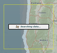
Process 2: After the LIDAR data is displayed, then press Add to Cart ![]() icon. As all data sets are loaded to the cart, press the
icon. As all data sets are loaded to the cart, press the ![]() Checkout button to download it.[/vc_column_text][vc_separator style=”double” padding_top=”15″ padding_bottom=”15″][/vc_column][/vc_row][vc_row][vc_column][vc_column_text]
Checkout button to download it.[/vc_column_text][vc_separator style=”double” padding_top=”15″ padding_bottom=”15″][/vc_column][/vc_row][vc_row][vc_column][vc_column_text]
2. USGS Earth Explorer:
USGS provide free LIDAR data of the USA, before it was provided by the CLICK (Center for LIDAR Information Coordination and Knowledge). Now you can access this information through Earth Explorer web map. Get registered your username to download the data.
Process 1: Search the area of interest ![]() or find the desire location by zooming in to the area. Then press
or find the desire location by zooming in to the area. Then press ![]() use map icon to get the coordinate values. After this click on the
use map icon to get the coordinate values. After this click on the ![]() icon which will take you to the next window.
icon which will take you to the next window.
Process 2: Check the LIDAR option ![]() and click the Results
and click the Results 
Process 3: You have to register to download the free LIDAR data, click on the download  icon of your desired LIDAR image. It will take you to the downloading window.[/vc_column_text][vc_separator style=”double” padding_top=”15″ padding_bottom=”15″][/vc_column][/vc_row][vc_row][vc_column][vc_column_text]
3. United States Interagency Elevation Inventory:
The best sources of the LIDAR data is from the United States Interagency Elevation Inventory (USIEI). It started by the collaboration between NOAA and the U.S. Geological Survey, with the help from the Federal Emergency Management Agency (FEMA). To download the LIDAR data the process is not that simple, they have a web map through which you can download the data.
Process 1: Choose the name of the desired states and then select the desired county name

Process 2: After searching the data which might take few seconds, at the bottom it will display all data of the Baldwin County.

Process 3: Click your desired row that will take you to the right website from where you can download the data.[/vc_column_text][vc_separator style=”double” padding_top=”15″ padding_bottom=”15″][/vc_column][/vc_row][vc_row][vc_column][vc_column_text]
4. National LIDAR Dataset (United States):
Wikipedia maintains sources of the free LIDAR data of each state of the United States. Getting to the right place to get the desired data might be little bit overwhelming.[/vc_column_text][vc_separator style=”double” padding_top=”15″ padding_bottom=”15″][/vc_column][/vc_row][vc_row][vc_column][vc_column_text]
5. Open Topography:
Open Topography is the public domain where users upload their data for public to have access of high quality topographic and bathymetry data. Open Topography system is based on the San Diego Supercomputer center at the University of California.
Process 1: Register as a user to download the point cloud data, non-register users can only download KMZ extension file, good for google earth only.
Process 2: Click on the red icon  to download the LIDAR data.

Process 3: Click on the Data set name
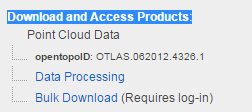
Process 4: Go to the Download and Access products heading in the middle of the page to download the data.
Other Countries Free LIDAR Data:[/vc_column_text][vc_separator style=”double” padding_top=”15″ padding_bottom=”15″][/vc_column][/vc_row][vc_row][vc_column][vc_column_text]
6. GEOSUD:
French website maintains the access of Free LIDAR data of few countries. These countries are from Europe, Asia, Africa and South America, go to their map to see list. Website is in the French, you switch to English using google translator.
Process 1: Go to the map to select the country of your interest and then click on the country boundary (example France) which will take you to the next page.
Process 2: Click on the data link to download it.[/vc_column_text][vc_separator style=”double” padding_top=”15″ padding_bottom=”15″][/vc_column][/vc_row][vc_row][vc_column][vc_column_text]
7. gipuzkoa.net (SPAIN):
The LIDAR data of the North of Spain is free which can be accessible by visiting their English version web map. Click on the grid map to download the data. Data are in LAS files of 1 sq km. There reference system is EPSG:25830 – ETRS89 / UTM zone 30N. This data can be also downloaded from FTP site maintain by the gipuzkoa government, this ftp version have data from 2012 too. (Source: researchgate.net)
Spain government has provided free LIDAR data, you can directly download from their website, DOWNLOAD[/vc_column_text][vc_separator style=”double” padding_top=”15″ padding_bottom=”15″][/vc_column][/vc_row][vc_row][vc_column][vc_column_text]
8. Free LIDAR data for the United Kingdom:
Centre for the Environmental Data Archival maintains the Free LIDAR data of the United Kingdom. You can download 1m resolution data. To have the access of the data you need to register.
 [/vc_column_text][vc_separator style=”double” padding_top=”15″ padding_bottom=”15″][/vc_column][/vc_row][vc_row][vc_column][vc_column_text]
9. Free LIDAR data for Philippines:
You can download Phillipines LIDAR data from the LIPAD website.

[/vc_column_text][vc_separator style=”double” padding_top=”15″ padding_bottom=”15″][/vc_column][/vc_row][vc_row][vc_column][vc_column_text]
10. Extra Resources for Students:
Sample LIDAR Data for School Works: When you are doing the course work, you need sample free LIDAR data. So I am including few links from where you can download the data.
http://www.liblas.org/samples/
Australia Free LIDAR Data: http://tern-auscover.science.uq.edu.au/
http://kos.informatik.uni-osnabrueck.de/3Dscans/[/vc_column_text][vc_separator style=”double” padding_top=”15″ padding_bottom=”15″][/vc_column][/vc_row][vc_row][vc_column][tagline_box call_text=”NOW READ:” call_text_small=”10 Most Popular LIDAR GIS Tools Available in Market” title=”READ” color=”blue” margin=”0″ href=”http://grindgis.com/blog/10-most-popular-lidar-gis-tools-available-in-market”][/vc_column][/vc_row]

Anonymous
27 May 2016GEOSUD: the portal is not accessible without registration anymore.
alex
3 Jan 2017just want to share an info (and because i can not make a comment in the gis.stackexchange forum) that there is a country in asia that openly shares lidar datasets (though not wall to wall coverage yet). this is the country of the philippines. here’s the site:
https://lipad.dream.upd.edu.ph/
admin
3 Jan 2017Thank you Alex, I will add on the list
Zubair Bangroo
12 Mar 2019Hi All,
Is there any free LIDAR data for Himalayan Region for Glacier study?????