
1. Introduction
1.1 What is Remote Sensing an Overview
1.2 Electromagnetic radiation and spectrum
1.3 Interactions with the Atmosphere
1.4 Passive and Active Remote Sensing
2. Sensors and Satellites.
2.2 Satellite Characteristics and Resolution Properties
2.3 Multi spectral and Thermal Imaging
2.4 Types of observational satellites
3. Image Analysis
3.4 Enhancements and classification
4. Applications in general
4.2 Forestry, Geology and Hydrology
4.3 Land use land cover, Ocean and Coastal monitoring and Sea Ice
1. Introduction
What is Remote Sensing?
So what is Remote Sensing? For the purpose of this study we can use the following definition:
“Remote Sensing is the art and science of acquiring information about the earth surface without having any physical contact with it. This is done by sensing and recording of reflected and emitted energy.”
In the process of Remote Sensing involves an interaction between the incoming radiation and interest of target. This is done by using imaging and non-imaging system; however the following steps are involved in the process
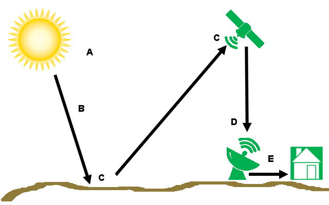
a. Energy Sources:
The first and most important requirement for a Remote Sensing system is an ideal energy source or illumination which provides electromagnetic radiation to the Target interest.
b. Atmosphere and Radiation:
As the energy traveling from its source to Earth surface, it will come in contact with atmosphere when it passes through. This is also happening when the energy from target reflected bake to sensor.
c. Interaction with the Target and Recording of the Reflected Energy
Once the energy is passed through the atmosphere, it interacts with the target object and depending upon the physical and chemical properties of the Target the energy is reflected or emitted back the Sensor collect and record the Electromagnetic radiation.
d. Transmission and Ground level Processing
After the energy sensed it has to be transmitted in the form of electronic signals to the ground stations for processing and generate the output as image (Hard copy/Soft copy). The processing involves various steps that we will discuss in later.
e. Interpretation, Analysis and Application.
The processed image is interpreted visually and digitally using various interpretation Techniques to extract the information.
The final step is that we are applying the extracted information on various fields of our studies. It may reveal some new information about which the target. The data we gained through Remote Sensing may not be able to collect it through other conventional methods. The applications are infinite.
The five headings are the major elements in Remote Sensing from beginning to end. The following chapters will be covering these main headings.
1.1 Electromagnetic Radiation (EMR)
The first and most important component of Remote Sensing is the Energy source to illuminate the Target. The energy is in the form of Electromagnetic Radiation. It is either natural originating from the Sun or earth by emission, or by artificial means. Electromagnetic energy refers to all the energy that moves with the velocity of light in a harmonic wave pattern.EMR consists of an Electrical field and Magnetic field. The electrical field varies magnitude in a direction perpendicular to the direction in which the radiation is travelling and magnetic field oriented to the right angles to the electrical field.
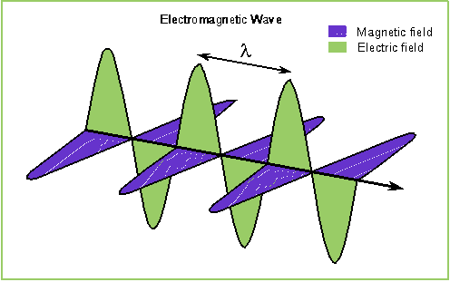
Wave Lengths :
A Wave length means the length of one wave cycle or the distance from any position in a cycle to the same position in the next cycle. It is usually represented by Greek letter lambda (λ). Wave length is usually measured in micrometer (mm, 10-6m) and the nanometer (nm,10-9m).
Frequency:
Frequency refers to the number of wave crests passing in a given point in Specific unit of time. It is normally measured in hertz (Hz). Wave length and frequency is related to following formula
ν = c / λ
v = Frequency c = Speed of Light λ = Wavelength
Therefore, these two are inversely related to each other. The shorter wave length, higher the frequency and vice versa.
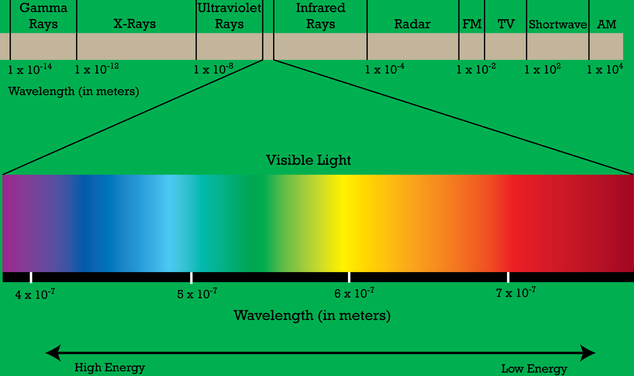
1.2 Electromagnetic Spectrum
The Electromagnetic Spectrum ranges from kilometers to nanometers. These are divided by ranges called Spectral bands. There are several regions in the Electromagnetic spectrum which is useful for Remote Sensing. The following image shows the various regions in EMR.
|
Region name |
Wavelength range |
Details |
|
Ultraviolet (UV) |
0.30-0.38 μm |
Very narrow zone of EMR. It has short wave lengths. Largely scattered by atmospheric particles. |
|
Visible |
0.4-0.75 μm |
These regions are highly used for Remote Sensing.
Blue, Green and Red are the primary colors in the visible spectrum. |
|
Near Infra red (NIR) |
0.75-1.5 μm |
Frequently using in Remote Sensing.
|
|
Middle Infrared (MIR) |
1.5-5 μm |
Comprises of
Both the regions are highly using in Remote Sensing. |
|
Thermal Infrared (TIR) |
5.0-15.0 μm |
Long wavelengths, Much of this energy is comprised of emitted radiation from the Earth. |
|
Microwave |
1mm-1m |
Longest wavelengths using in Remote Sensing. Using in Both active and Passive mode. These signals can penetrate into clouds and fog. |
1.3 Interactions with Atmosphere
When the incoming solar radiation passes through the atmosphere it may come in contact with atmospheric particles and gases, leads to the mechanisms of scattering and absorption. The gases absorb the Electromagnetic radiation at specific wavelengths called absorption bands. However the high interviewing transmittance regions are often known as Atmospheric Windows.
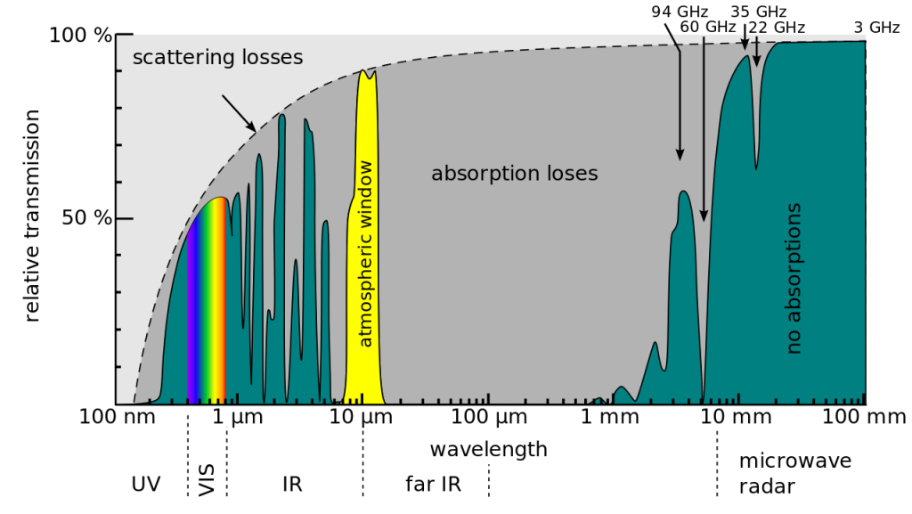
image source: commons.wikimedia.org
A. Scattering
When the incoming radiation and light passes through the atmosphere it will affected by the atmospheric particles and this will result the redirection of the light from its original path is known as scattering. The amount of particles present in the atmosphere, wavelength of radiation and the distance of radiation travels through the atmosphere are the major elements which influences the amount of scattering. Following are the major types of scattering.
B. Rayleigh scattering
Rayleigh scattering occurs when particles are very small when compared to incoming solar radiation. The small particles of dust, nitrogen and oxygen molecules are causing such type of scattering. The effect of Rayleigh scattering is much more in shorter wavelengths than longer wavelengths. The phenomena of sky appears blue during the day time is because of the Rayleigh scattering the shorter wavelengths of visible spectrum (Blue) scattered more than that of longer wavelength.
C. Mie scattering
Unlike Rayleigh scattering, Mie scattering occurs when the incoming solar radiation and the atmospheric particles have the same size. Dust, pollen, smoke and water vapour are causes Mie scattering which tend to affect longer wavelengths than those affected by Rayleigh scattering.
D. Non selective scattering
This occurs when than particles size is much larger than the radiation. Water droplets and dust particles can cause this type of scattering. Non selective scattering gets its name from the fact is that it scattering all the wavelengths equally.
B. Absorption
Absorption is another main mechanism that happens when the EMR interacts with atmospheric particles and gases. When the EMR passes through the atmosphere the molecules in the atmosphere absorbs energy at various wavelengths. Ozone, CO2 and water vapour are the main causes of energy absorption.
Ozone absorbs the harmful ultraviolet rays of incoming solar radiation. This also causes to avoid the ultraviolet rays from Remote Sensing sensors.
Carbon dioxide is referred as the green house gas. CO2 tends to absorb the far infrared portion of the spectrum and traps inside which causes the heat inside the atmosphere.
Water vapour in the atmosphere absorbs the incoming long wave infrared and short wave microwave radiation (between 22 μm and 1m).The presence of water vapour in the atmosphere varies place to place.
1.4 Passive and Active Remote Sensing
So far, throughout this chapter we discussed various Remote Sensing techniques. There are two types of Remote Sensing Systems namely Active and Passive sensing. Passive sensing means the sensor uses Sun’s energy as the source of illumination and active sensing means the sensor emitting the energy to the target and collecting the reflected energy. Some examples of active sensors are fluorosensor and Synthetic Aperture Radar (SAR).
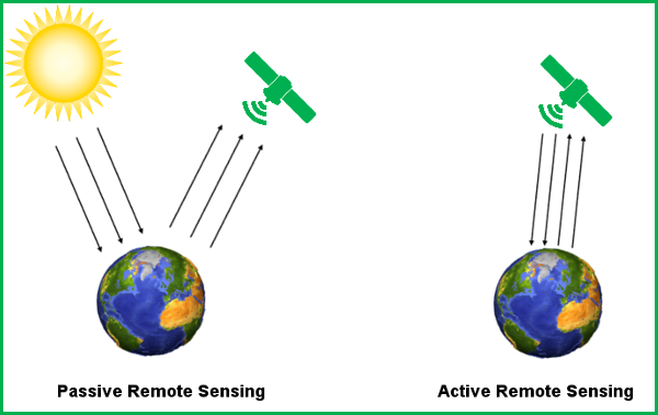
The main disadvantage of passive sensors is that they can collect or detect objects in the day time only because sun’s illumination is not there at night, however they can record the naturally emitted energy like Thermal infrared. On the other hand Active sensor gives own energy for illumination so it enables to detect and record the images at any time. They are weather independent also; artificial microwaves can penetrate clouds, light and shadow. But Passive sensors are not weather independent. Radar signals can penetrate into vegetation and soil and even can give you the surface information at mm to m depth level at the same time major disadvantage is that radar signals do not contain any spectral characters while Passive Remote Sensing signals have spectral characters. Unlike active sensors passive sensor have the ability to produce fine resolution image. Active Remote sensors are cost intensive also when compared to passive sensor.
2. Sensors and Satellites
In the previous section we made discussions about Remote Sensing energy components and its physics. In here we are going to discuss about the collection of reflected energy. It is the responsibility of the sensor to detect and capture the emitted or reflected energy from the target. In order to capture the energy, the sensor must reside on a stable surface called Platforms. Different types of sensors are there on the basis of Platforms.
2.1 Sensors and Types
As above said, to collect the reflected or emitted energy the sensor must reside above the target. It may be ground based (lies within the Earth’s surface), Aircraft based and Satellite based (lies outside of the Earth’s surface).
Ground based sensors are using to record to collect the detailed information about the Earth surface. The data collected by ground based sensor is used to compare the data collected by other sensors like satellite based or to understand the surface features more detailed. One advantage is that the atmospheric disturbances are absent in this type of sensing. The sensor may place on a ladder, scaffolding or crane etc.

Aircrafts are the major platforms in Aircraft based sensors. Helicopters are also occasionally using. Aircrafts are using to collect the detailed information about the Earth surface at any time. Major disadvantage is that it is not possible to fly aircrafts at bad weather.
In the space remote sensing are conducted from either using Space shuttle or Satellites. These kinds of Satellites are often known as Remote Sensing satellites. Satellite based sensors are the most efficient and wide spread in the world. These can give a global level coverage but it is costly. Cost is often an important factor while choosing the sensor.

2.2 Satellite Characteristics and Resolution Properties
So far we learned about the Remote Sensing techniques, platforms and sensors and also about Satellites. These satellites have some characteristics that makes this is a unique platform in Remote Sensing sensors.
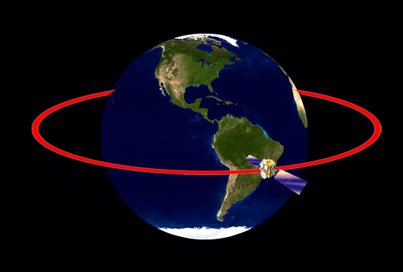
Orbits
The path which is followed by satellites is referred as Orbit. Orbits vary along with their altitude and their orientation and rotation related to the Earth. The orbital change is also influences the satellite’s view of earth portion.
To monitor a particular place regularly in the earth surface we are using geostationary orbits. The satellites following the same orbit are called geostationary satellites. This orbit has a very high altitude of 36000KM approximately. The satellites revolving through the orbit have a speed match with the rotation of Earth. This allows monitoring a particular place continuously.
image source: h2physics.org
Sun synchronous orbit or polar orbit: some satellites are designed to follow a north south (pole to pole) direction of orbit called Polar orbit. These satellites cover the local time (regularly), referred as Sun synchronous satellites. At any given latitude the, the position of the sun in the sky as the satellite passes overhead will be the same within the same season. This enables the consistent illumination conditions when acquiring images of specific season over successive years.
Resolution Properties
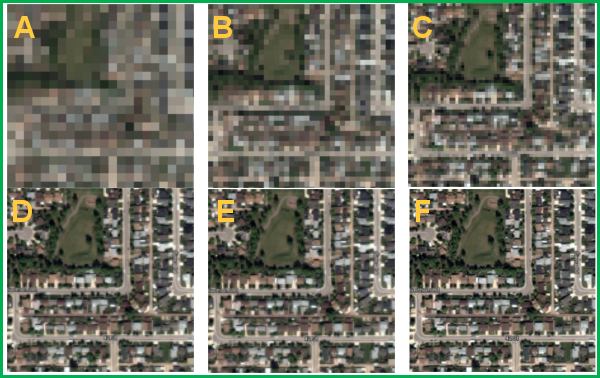
Some instruments taking images from very high altitude and it may give a global coverage or country level coverage. It is not possible to extract information about your home from the global level coverage. In order to extract information we have to design a new sensor to provide Centimeter level information. While designing the sensor or using the output image we have to look up about resolution. There are four distinct types of resolutions are there they are
Spatial Resolution
The ability of the sensor to detect the smallest single object in the Earth surface is referred as Spatial Resolution. Extraction of details from the image is highly depends upon the spatial resolution. Spatial resolution of the sensor is highly depends on their Instantaneous Field of View (IFOV).IFOV is the angular cone of visibility of the sensor. It determines the area of the Earth’s surface which is “seen” from a given altitude at particular moment of time. The size of the area viewed is determined by multiplying IFOV by the distance from the ground to the sensor.
Spectral Resolution
Simply we can define as the ability of the sensor to record the information on a particular spectral range is called Spectral Resolution or the ability of the sensor to define fine wavelengths. Spectral resolution is highly important while designing the sensor. It defines the nature of the study. Different objects have different spectral signature.
Temporal Resolution
Like other resolution properties temporal resolution is also important in Remote Sensing studies. Temporal resolution means the revisit of the satellite over the particular area at same interval of time. The temporal resolutions of the satellites are usually several days which enable to capture the images of an area regularly and can monitor well. The images collected over a given interval are called multi-temporal data, which is the main advantage.
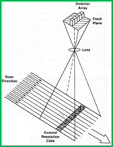
2.3 Multi spectral and Thermal Imaging
Remote Sensing instruments are acquiring the data by scanning the Earth surface. Different types of scanning systems are using in Remote Sensing for acquiring the data.
Multi spectral Scanning
A scanning system collecting data over a various wavelengths but not continuous is referred as Multi spectral scanning system. It is the most commonly using scanning system in the world. There are two methods are deployed in the multi spectral scanning system for acquiring information about the Earth surface. They are follows.
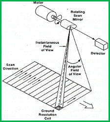
Across Track scanning
Across Track scanning scans the surface in a series of lines. These lines are perpendicular to the direction of the motion of the sensor. Each line is scanned from one side of the sensor to another side. This is done by using rotating mirror. This type scanning is also known as whisk broom scanning
Along Track Scanning
This type scanning uses a forward motion of the sensor to detect the successive scan lines and these lines are perpendicular to the flight direction. These systems are also referred as push broom scanning system. Instead of rotating mirror here using a linear array of detectors located I the focal plane of the sensor.
Thermal imaging
Multi spectral systems usually using reflected energy for acquiring the information, while unlike them Thermal imaging is using emitted energy like thermal infrared spectrum (3 μm to 15 μm) for acquiring data. Unlike multi spectral system Thermal sensors using photo deters sensitive to direct contact of photons on their surface, to detect emitted thermal radiation. This detectors are cooled (Temperature below 0°C) for avoiding their own emission. These sensors are measuring the surface temperature of the target. Thermal Imaging is typically using the across track scanning system. Thermal sensors normally have large IFOV to ensure enough energy reaching to the sensor to make reliable measurements.
Major Earth observational satellites and their sensors
|
Satellites |
Sensor |
Band width |
Spatial Resolution |
Temporal Resolution |
|
Landsat
|
MSS 4-5
|
0.5-.6 0.6-.7 0.7-.8 0.8-1.1 |
80M |
16 days |
|
TM 4-5 |
0.45-0.52 0.52-0.60 0.63-0.69 0.76-0.90 1.55-1.75 10.40-12.50 2.08-2.35 |
30M |
16 days |
|
|
|
0.45-0.515 0.525-0.60 0.63-0.69 0.75-0.90 1.55-1.75 10.40-12.5 2.09-2.35 PAN 0.52-90 |
30M |
16 days |
|
|
Spot 4 |
X1 X2 X3 X4 |
0.50-3.59 0.61-0.68 0.79-0.89 1.58-1.75 |
20M |
26days |
|
IRS 1C |
LISS 1 LISS2 LISS3 LISS4 WIFS 1 WIFS 2 |
0.52-0.59 0.63-0.68 0.77-0.86 1.55-1.70 0.62-0.68 0.77-0.86
|
23.6M |
24days |
|
Ikonos |
Multispectral
Panchromatic |
0.45-0.53 0.53-0.60 0.63-0.69 0.76-0.90 0.45-0.90 |
4M “ “ “ 1M |
2.9 days |
3. Image Processing and Analysis
3.1 Introduction
In order to take the benefit of the Remotely Sensed data we have to extract the meaning full information from the image. This is discussing in this secession. Interpretation and analysis of remotely sensed image involves the identification of the target it may be an object or feature in the Earth surface. We can extract the information and analysis either by manual method or aided by computer. Before making computer aided techniques, it is better to extract and identify feature manually called Visual interpretation. Much identification and interpretation of the targets in Remote Sensing are done by visual interpretation i.e. human interpreter. The computer aided techniques called Digital Image processing is simplifying the visual interpretation. It may be used to enhance the data like enhancing the brightness of the data.
3.2 Visual Interpretation
As we noted above many of the Remote Sensing studies using human interpretation or visual interpretation techniques. How we can do a visual interpretation? There are certain elements are there which makes visual interpretation easier. They are
Tone refers to the brightness or color of the image. Tone is an important element in identifying target. Variations in tone enable to identify the target along with other elements like shape, size etc.
Shape the general form or structure of the individual objects. Shape is the most helpful interpretation technique. Shape of a sharp edge may be an agricultural field rather than a naturally created forest.Linear shape of the road and rail way makes it easy to identify.
Size of objects in an image is function of scale. It is important o assess the size of the target relative to other objects in a scene, as well as he absolute size, to aid the interpretation of the target. For example if an interpreter identified an area having larger buildings such as factories or war houses then it may be an industrial region while a clustering of small building indicates they may be a settlement area.
Pattern means the spatial arrangement of visibly discernible objects in the image. Pattern helps to identify objects having similar characteristics like orchard have evenly spaced tress which may show a similar pattern which makes identification easier. Regularly spaced villas are another example of same pattern.

Texture is the arrangement and frequency of tonal variations in particular area of an image. Several types of textures are there like rough texture and smooth texture. Smooth texture will have uniform, even surface and little tonal variations. Grassland is a typical example for smooth texture. While rough texture may change tonal variations abruptly. Texture is one of the most important elements for distinguishing features in Radar imagery.
Shadow can help the interpretation easier at the same time it can reduce interpretation. It can provide the idea about the relative relief of the target which makes identification easier. While if the shadow falls on an object it will hide that object and it makes much difficult to interpreter.
Association means simply the relationship between nearby objects or feature to the target. One would be expected to associate other like play ground in the schools. This makes identification easier.
3.3 Digital Image processing
Today most of the remote sensing data is recording in digital formats. These data is storing in various formats like BSQ (Band sequential), BIP (Band Interleaved by Line) and BIP (Band interleaved by Pixel) and so on and these images are undergoing various image processing steps. Digital image processing involves numerous procedures including correction of data, image enhancements for better visualization, fully automated classification or interpreter aided computer classification of the images and so on. Minimum facilities are required for image processing system is that a computer with necessary hardware which meets the requirement for image processing and a good software package and Remote Sensed image (in digital format).Several commercial software packages are available in the market. All these systems are collectively known as Image analysis system. The major image processing functions can bring under three main heading as follows .
- Preprocessing
- Image enhancement and
- Image classification and analysis
Preprocessing
Preprocessing is usually done prior to the main analysis. These are sometimes referred as image rectification and restoration. Preprocessing is indented to correct the platform, sensor radiometric and geometric distortions in the data. Radiometric corrections are done to stabilize the illumination variation and viewing geometry. These are happening due to distortion in platforms and sensors. It can be corrected by modeling the geometry relationship and distance between the areas of the Earth surface imaged. Noise of the image may be due to the errors or distortions occurring while recording the data. Common forms of noise include systematic striping or banding and dropped line it should be corrected before the enhancements are doing.
3.4 Enhancements and classification
Enhancement techniques are applied to digital imager prior to visual image interpretation. This optimizes the imagery for visual interpretation purpose. Even we have done radiometric corrections in the image to reduce the noise and other atmospheric disturbances still may be in the image and is not optimized for visual interpretation. If the image have large variations in spectral responses from variety of targets, simple radiometric correction can’t optimize he image in its all portions .For each application and each image a custom enhancements are needed. To understand enhancement techniques it is better to understand the term image histogram. A histogram is a graphical representation of the brightness values that comprise an image. The brightness values are plotted in X axis and the frequency of occurrence of each of these values in the image shown on the Y axis.
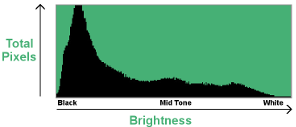
Figure: Image Histogram
Contrast enhancement is an enhancement technique normally involving changing the original values so that more of the available range is used, thereby increasing the contrast between targets and their backgrounds. Linear Contrast Stretching is the simple type of enhancement techniques involving identification of minimum and maximum brightness values in the image and applying to stretch this range to fill the full range. Histogram equalization is another technique. This is a non linear stretch. In this method the DN values are redistributed on the basis of their frequency. More efficient gray tones are assigned to the frequently occurring DN values of the histogram. Spatial filtering is a technique which involves noise reduction (Low pass filter) and edge enhancement (High pass filter).
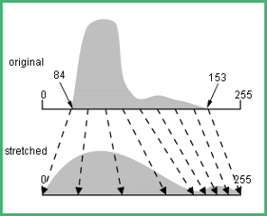
Figure: Linear Contrast Stretching
Digital Image classification the computer classifies the image by DN values of each pixel on the basis of spectral responses. It may be either fully automated referred as Unsupervised classification. Here computer classifies the image and interpreter says only how many classes (Building, forest, agricultural lands and so on) he wants and based on that the system generates the classified image. Supervised classification is another method involves the interpreter have regulations on the classification. Interpreter identifies the pixels of each class and assigned to computer and based on that the computer classifies the image.
4. Applications in General
So far the previous sections we are discussed about various techniques in Remote Sensing, data capture, process, interpretation and classifications. Now here we are going to discuss various applications of these images. Each application may have their needs like particular spectral bands, spatial resolution and revisit time. The major applications are following.
4.1 Agriculture
Agriculture have major role in economies of both developed and developing countries. Remotely sensed images are used to map the crops to examine their health and farming practices. The major applications are follows.
- Crop type classification
- Crop condition assessment
- Crop yield estimation
- Mapping of soil characteristics
- Farming practices monitoring
4.2 Forest
Forest is the most valuable one for almost all living things in earth. It gives food, shelter and fresh air to living organisms but some time due to anthropogenic and natural reasons forest may get cleared. But efficient Remote sensing system can monitor it well. The main applications of Remote Sensing are follows.
- Forest type discrimination mapping
- Agro forestry mapping
- Forest inventory
- Species inventory
- Forest regeneration assessment
- Biomass estimation
Geology
Geology is the study of earth’s rock types, landforms and their structure. Remote Sensing have wide range of applications on Geology as it studies about the Earth. The main applications are
- Lithological mapping
- Mineral exploration
- Hydrocarbon exploration
- Geo hazard mapping
- Event mapping and monitoring
- Structural mapping
- Lineament mapping
Hydrology
It deals with the water sources in the Earth. Monitoring the precious water sources is a major application of Remote Sensing. Using Remote Sensing even we identify the polluted water using spectral signature. Major applications are.
- Wetlands mapping and monitoring
- Drainage basin modeling
- Flood mapping and monitoring
- River dynamics monitoring
- Irrigation scheduling
- Ice monitoring
4.3 Land use Land cover
Land cover refers to the surface cover on the ground while land uses referrers to the utilization of the land. These can make easier using Remote Sensing.
- Urban sprawl monitoring
- Natural Resources management
- Political boundaries delineation
- Wild life habitat
- Infrastructure planning
- Land use land cover classification
Ocean and Coastal monitoring
Ocean is major element in Earth’s biophysical system. But presently all the oceans are polluting .By using Remote sensing we can efficiently monitor not only the pollutions but also various oceanic parameters as follows
- Oil spill monitoring
- Ocean pattern identification including
- Current and Circulation patterns
- Upwelling zones and shallow bathymetry
- Storm forecasting
- Water quality monitoring
- Phytoplankton concentration
- Aqua culture inventory
- Sea surface temperature monitoring
- Navigation routes
- Operational fisheries surveillance
- Coastal Zone management and delineation
Sea Ice
It covers the significant portion of the earth surface and a major factor in commercial shipping and fishing industries .Major applications are
- Ice berg detection and tracking
- Surface topography
- Ice concentration
- Ice type / motion
- Pollution monitoring
- Sea level rise detection
- Meteorological monitoring
References:
- http://www.seos-project.eu/modules/remotesensing/remotesensing-c02-p02.html
- http://eijournal.com/print/articles/exploring-the-benefits-of-active-vs-passive-spaceborne-systems
- Fundamentals of Remote Sensing tutorial by Canadian Natural resources centre.
- Fundamentals of Remote Sensing Edited and written by Noam Levin- 1999
- Physical Basis of Remote Sensing by DS .Boyd, School of Earth sciences and Geography, Kingston University U K (Geo informatics volume- I)

Martin
25 May 2015Great article on the basics of remote sensing!
Also congratulations on your great blog. I will definetly come back.
Best regards
Martin
admin
26 May 2015Thank you Martin, I appreciate for your comment.
dauda balami
26 May 2015very easy and straight forward for a beginner.
admin
26 May 2015Thank you Dauda, appreciate for your comment. I am still working on this article esp with pictures. Once it is done, I will update you.
vladimir lopez garcia
26 May 2015interesante pero nono se si podrian complememntarlo con textos en pdf y sus tutoriales de manejo seria muy bueno
admin
26 May 2015gracias, I will try to create pdf version soon, still working to finish the image part.
admin
28 May 2015Vladimir, Now you can view the article in the pdf format. It is located on top of the page.
Tatek
30 May 2015First of all I would like to say Thank you for your information. It is interesting and vital for me!! thanks in advance. if you have documents related to Photogrammetry please could you share it!!
admin
1 Jun 2015I appreciate for your comment Tatek. Next week I will write article on the photogrammetry. I will update you when I will finish it. Once again thank you,
admin
24 Jun 2015I have finished writing about the photogrammetry, please go to http://grindgis.com/blog/basics-photogrammetry
MANIKANDABHARATH K
20 Jun 2015thank you sir
admin
21 Jun 2015Thank you MANIKANDA, I appreciate for your comment.
satyajit pradhan
9 Jul 2015i am GIS engineer, completed my M.Sc degree in remote sensing and GIS. it is a great blog for getting knowledge about RS,GIS,Phogrametry, etc. please share more article.Also share about GIS apllication on Telecommunication.
admin
9 Jul 2015Satyajit, Appreciate for your comment. I will write about it. If you have any great idea, please share with us.
salem youssef
15 Dec 2015Thanks so much for these great informations about the introduction and fundamentals of Remote Sensing Sciences and we wate the more
admin
15 Dec 2015Thank you Salem, I will.
Reza Panahi
6 Apr 2016Great information!
Could you please give more information in detail about the each satellite (e.g Ikonos). I mean history, country, production date, quality, etc.
Thanks again for your great information.
admin
6 Apr 2016Thanks Reza, definitely I will write it.
Oytisa Onato
17 Dec 2016This is a great blog! It taught and made me in touch with current techniques in GIS and Remote Sensing. It is really easy learn GIS and love geography!
admin
17 Dec 2016Thank You, Oytisa
IMMANUEL A
28 Dec 2016Easy to recall the whole about remote sensing in just mins.. Could u write Ground water potential and its research.. I feel it is essential for today’s world.
admin
28 Dec 2016Thanks Immanuel, I will
Sodangi
21 Jan 2017Excellent work. Highly recommendable
admin
23 Jan 2017Thank you Sodangi
Ritesh
8 May 2017Visible lights range is mistakenly written as 0.04 -….. It got me thinking.
Nice article… Thank you.
admin
9 May 2017Thanks Ritesh, I have updated it.
Frank Charles
27 May 2017guys..
electromagnetic energy reflected from the Earth surface is recorded by variety of remote sensing systems.Discuss
help please!
Prem
20 Dec 2017thanx bro…it is very helpfull….nd i got 10 marks in my exam from this article….
admin
28 Dec 2017Thanks Prem
Ramniwas vaishnav
21 Dec 2017Please enlarge information about its application in forest management and wildlife conservation
admin
28 Dec 2017Thanks, I will.
Charlotte Copp
1 Apr 2018This is a great article! I was wondering if the author could look at this project I have been working on. This project was created to engage with people on topics that could be debatable or unknown to them. It is meant for an opportunity for growth for the researcher (me) and the participant (you). So, at this link below you will find the survey. The instructions are simple, you’ll read the first section like any other blog post. I describe the importance of technology in scientific and conceptual ways, then I’ll prompt your input on remote sensing and satellite data collection.
I’ll ask you to choose a satellite layer to engage with, you’ll see a large scale map of information. Then you press participate and upload a photo of a place you would like to discuss. Then in the description, you will compare the map and the photo you chose.
I hope that all makes sense! Please reach out if you have any questions, I love hearing feedback.
https://ds.lclark.edu/copp/stories-through-the-birds-eye/
Manu P
28 Jan 2019Easy to recall the whole and straight forward for the beginars and I observed some spelling mistakes and at last thans a ton for your wonderful article.
Soliman Hossain
27 Jun 2019Great article on the basics of remote sensing!
Also congratulations on your great blog.
admin
9 Jul 2019Thank You 🙂
Consolee
10 Mar 2020Thank you for this basic remote sensing
Shahadat
30 Jul 2021Very helpful for us. Thanks
Balwez
9 Aug 2022it is briefly and great for me, thanks.