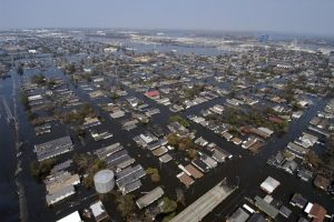
Photographs and other different images of Earth are taken from the air and space. Such images are captured to show the planet’s landforms, resources, and vegetation. There are various ways to capture aerial and terrain photographs. These include aerial and remote sensing photography.
Aerial photography produces photographic images from satellites, helicopters, balloons, or airplanes through a systematic overlapping flight pattern at a fixed altitude. It is primarily used for mapping.
On the other hand, remote sensing refers to the science of remotely acquiring, processing, interpreting, and presenting spatial data taken from a significant distance from the subject. They are videos and photographs taken from above within the electromagnetic spectrum.
Differences
1. Distance
Remote sensing imagery is captured from 600-1000km and covers a large area ranging from 3500 to above 30000 square kilometers. Satellite imagery cannot provide stereo views, but the stereo views can be attained from satellite altitudes.
Conversely, aerial photography images are taken from an altitude of a few hundred meters to thousand meters. It also covers a smaller area of utmost a few hundred square kilometers. Most of these photographs aim to take a stereo-view of a terrain.
2. Types of data
Remote sensing satellites collect various data, including; color infrared, thermal, radar data, and standard photographic imagery. Such varieties of datasets make satellites versatile. Despite this, they face a setback when there are technology improvements. Such advancements make it challenging to change the sensors and cameras in a satellite.
Conversely, in aerial photography, aircraft are mounted with several different cameras or sensors. It allows the swapping of capture devices but only when the plane is not airborne. They capture standard imagery, radar, and color infrared images. Therefore, it is easier to change the sensors, thus allowing the aerial acquisition to keep ahead of the latest advancements in technology.
3. Weather conditions effects
Remote sensing satellite surveys are not constrained by weather. However, clouds may conceal some information available on NIR bands.
Aerial photography surveys are adversely affected by the weather. For an airplane or helicopter to fly, the weather conditions have to be favorable.
4. Level of detail
Satellite images are taken from a distance of about 900km above the Earth’s surface. The photos are taken digitally, which can be further improved or enhanced. The degree of detail is restricted to pixel resolutions of the sensors.
On the other hand, Aerial photography snapshots are taken by cameras and photographic films from an altitude of a few thousand meters. The images are an analog record, so no further improvements are possible after obtaining the photographs. The photographs have a very high degree of detail.
5. Speed
Remote sensing satellites are capable of collecting large amounts of data in a relatively limited time frame. The advantage is that the more modern the satellites, the faster they lock on an area and take photographs. The sizes of the pictures are enormous as they allow a complete site to be captured in a small time frame and using fewer images.
Whereas, Aerial photography used to be a slow and time-consuming process. The size and shape of a geographical area to be captured determined the amount of time taken. Using airplanes to fly back and forth led to a series of overlapping photographs being taken. Despite this, modern cameras have made the process faster as data strips are recorded rather than individual frames.
6. Location
Remote sensing has an advantage in that satellite imagery of a particular location in the world can easily be obtained once a satellite is positioned. There is no need to cross different countries’ borders or go through government protocols that could delay the attainment of the images.
While in aerial photography, there is delayed surveys and image attainment depending on the location of the study. The surveying team has to be in the study area to ensure a weather window is not missed.


