Irrigation is among the significant inputs contributing to efficient and sustainable agricultural production. Irrigation is necessary for arid areas with no rain or during periods of inadequate rainfall. Research shows that food produced from irrigated lands is about 40% of the global food production when the estimated land is about a 300million hectares. As outlined below, remote sensing through aerial, space, lidar, and laser scanning has contributed immensely to efficient and proper irrigation management.
1. Mapping of Irrigated Areas
Assessment of irrigated areas is essential for managing water resources, especially in arid and semi-arid regions where irrigation uses the most significant volume of water. Water managers need a map of the irrigated area to plan efficient, rational water use in cases where water is limited. Data acquired from remote sensing techniques are helpful for mapping irrigated areas. Also, the sensors are integrated to monitor crops’ growing patterns under water deficit conditions easily.
2. Water Quality and Management
Water is unarguably the most essential and precious thing that any living thing cannot live without; life begins with water and is nurtured with water. The development and growth of crops depend on the water quality in various river stretches around the farm. Remote sensing in water quality and management is applied in assessing the suitability of water to be used for irrigation purposes.
3. Efficient Irrigation Management
Irrigation’s main challenge is ongoing water management in arid and semi-arid areas. Efficient irrigation management is fundamental because; it reduces nutrient leaching, helps to save fresh water and energy, and increases crop yield. The use of remote sensors can help farmers improve irrigation management for better production and increased water savings.
4. Modern Irrigation System and Planning
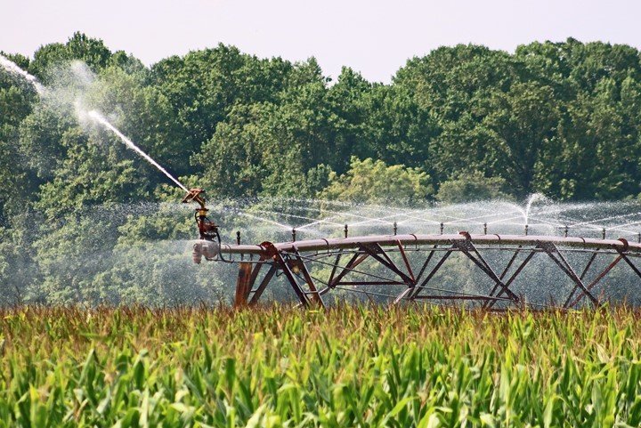
The modern irrigation system is all about the new technologies in the irrigation and drainage sector. They include; retooling drip irrigation technology, center pivot technology, smart irrigation management apps, and smart irrigation controllers. These improvements allow for increased efficiency and reduced energy costs in irrigation.
5. Development of Irrigation Infrastructure
Irrigation agriculture plays a significant role in determining the future food security of most nations globally. There is, however, increasing concern about the current infrastructure in the irrigation systems. Irrigation infrastructure refers to dams, aqueducts, canals, pumping plants, pipelines, and drainage. Remote sensing is a powerful tool that can harness infrastructure developments and land management.
6. Soil Erosion

The method used by a farmer to irrigate a given piece of land profoundly affects the vulnerability of that land to erosion. Farmers need to be conversant with information about irrigation and soil erosion, i.e., high flow rates of water can cause deterioration while low flow rates cause poor irrigation uniformity. Active remote sensing tools can provide detailed information about soil erosion.
7. Environmental Issues and Health
Most irrigation projects’ potential adverse environmental impacts include waterlogging, salinization of soils, and changes in dams and reservoirs. Possible health effects from irrigation could be increased water-borne and water-related diseases. GIS and remote sensing techniques help investigate these threats and develop proposed measures for mitigation.
8. Estimation of Land Surface Flows for Better Irrigation Management
Before irrigation, a farmer needs to determine the general land slopes of the farm to know the direction of the expected water flow. Examination of the land surface is done to avoid tempering crops, soil, and nutrients on the ground. Integrating satellite data in irrigation models helps estimate land surface flows for better irrigation management.
9. Assimilation of Satellite Data in Irrigation Tools for Monitoring Water Consumption
Remote sensing plays a significant role in improving irrigational water management. Satellite remote sensing is a low-cost solution for monitoring irrigation water use in developed and developing countries. The technique is applied to measure the amount of water consumed by a given land after irrigation.
10. Land Use
Land use describes the use of land for different purposes. Detecting irrigated areas requires land use and land cover maps combined with their evapotranspiration and precipitation data to distinguish irrigated from non-irrigated crops. Since irrigators are interested in knowing the use of lands, remote sensing techniques solve this by providing a categorical classification of data often interpreted from land cover.
11. Crop Production

The primary purpose of irrigation is to produce crops with economic and social value to society. Therefore, remote sensors are applied in irrigation to increase crop yields, reduce risks, increase product quality, reduce pests, and deliver the best nutrients for growth. Accurate time monitoring and managing irrigation operations by the sensors increase crop production.
12. Modernization and Automation
Irrigation is every farmer’s primary concern. Modern irrigation techniques like the drip irrigation system and sprinkler system have been introduced to improve farm water delivery service. Modernization and automation of irrigation tools enhance efficient water management hence increasing yields. Remote sensors in irrigation convert irrigation machines to electronically programmed sprinklers. Wireless robot systems are then improvised to facilitate irrigation.
13. Diversification of Crops
Diversification of crops increases food security and profitability because farmers can grow and sell various crops. Remote sensors provide the basis for information about the diversification of crops by evaluating the crop types, conditions, and yields. Parameters such as rainfall and soil texture are analyzed to assess the crops that grow well in less water and those that require excess water. Data from the sensors enables farmers to know when to diversify their crops.
14. Improving Water Use Productivity
Remote sensing in irrigation management is applied in assessing water availability in reservoirs for optimal water control. The available water should meet the irrigation demand of a given region. The remote sensing technique provides technical disciplines that educate on how to bring water to the root zone and the quantity of water used.
15. Soil Degradation
Declining soil quality after irrigation significantly impacts agricultural development and production. Soil degradation can cause loss of organic matter, a decline in soil fertility, and adverse changes in alkalinity, salinity, and acidity. Mapping and monitoring soil degradation using remote sensors is vital for successful irrigation management.


