Applications of Lidar in Agriculture

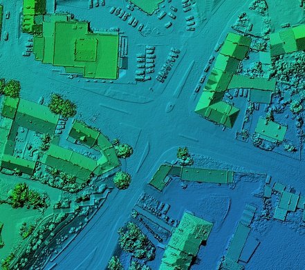
Light Detention and Ranging (Lidar) is a detention system that uses lasers to examine the earth's surface. It uses airborne tools to examine to collect spatial information. The technology uses…

0 Comments

Applications Of GIS Land Use Mapping

Effective land use and facilities design require in-depth knowledge of the site's physiography, hydrology, climate, human geography, and infrastructure. Before breaking ground, evaluate your long-term facility's location, environmental conditions, and…

0 Comments

Applications of multilinear maps

A multilinear map is a map with several variables. Each variable is linearly separated in multilinear maps, and these variables are vector spaces. Thus, a multilinear map takes some vector…

0 Comments

Uses of Radar in the military

Radar is a system that works on high-frequency signal out transmission toward a target. After the signal bounces back from the target and returns, the radar uses the received information…

0 Comments

Applications of Thematic Maps

As its name suggests, thematic maps illustrate the relationships between themes (subject) and the selected area. It shows a specific topic's spatial distribution and geographical patterns (themes). Before producing these…

0 Comments

Applications of Soil Maps

Soil is one of the most crucial components of the environment. Scientists and geographers use various tools and techniques to study and analyze the soil. Cartographers and agriculturists rely on…

0 Comments

What are karnaugh maps used for?

Karnaugh map is a technique or method in mathematics that is used to simplify Boolean algebra. The technique is a visual method used to simplify Boolean expressions pictorially. Therefore, a…

0 Comments
Close Menu